_INTRODUCTION_
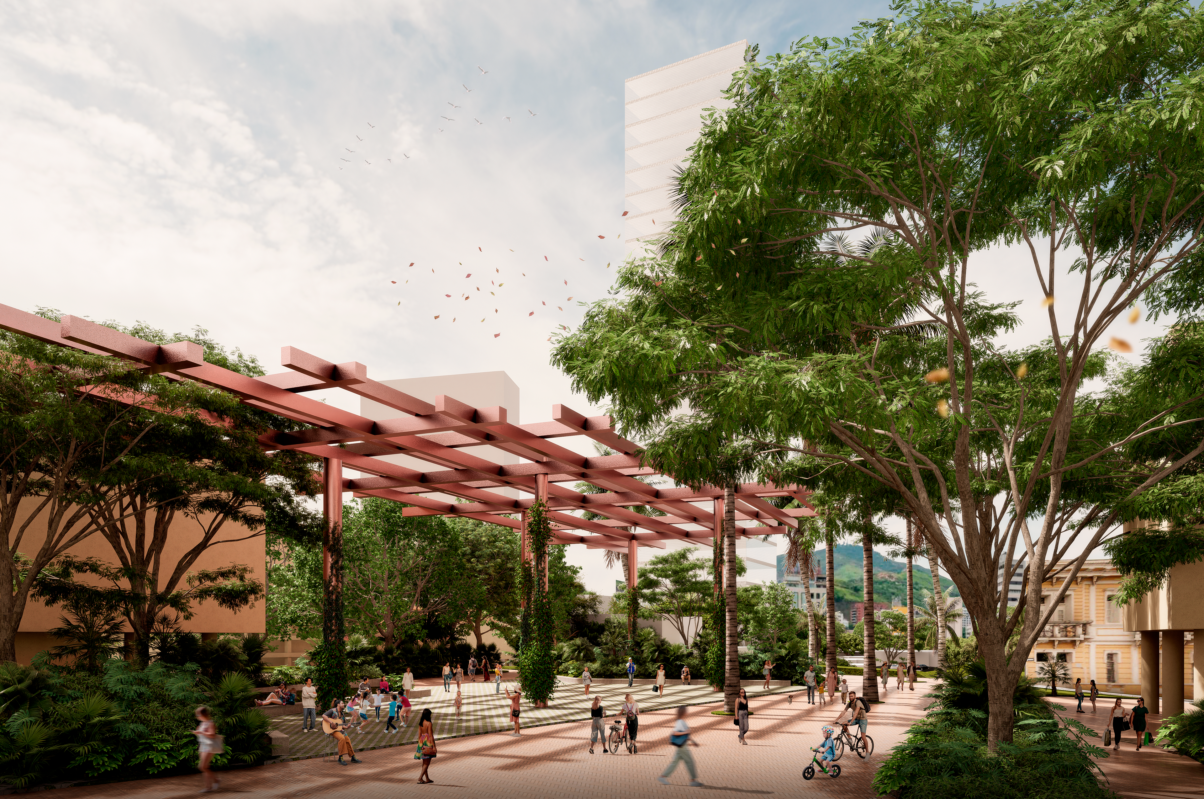
From an infrastructure that favors the car, speed and an unreadable landscape to a porous place of pauses and stays that highlights the urban landscape and facilitates appropriation.
The project is understood as a cultural valley that seeks to reconfigure, renaturalize and rehumanize the infrastructure, slowing it down and turning it into a place of permanence and meaning, structuring a site of scattered fragments in the unity given by a learning walk that weaves actors, dynamics economic and cultural, urban systems and a future look that comes from a narrative of the history of the city and the department through a pedagogical leisure that seeks to strengthen the civic culture by valuing the pre-existing heritage. It is about starting from the existing values and recognizing the current unsustainable condition as starting points to achieve an approach that achieves sustainability in an integral way.
_MASTER PLAN_
_Main objective_
Achieve an integrality that articulates the plan from the physical, technical, socioeconomic, cultural, financing and management aspects in a look that collects memory, with a future vision aimed at generating a strengthened identity and urban and social regeneration.
_Specific objectives_
1. Physical-technical. Update the infrastructure by converting the systems that today fracture the territory into systems to weave public space, the ecological structure and activity, taking the vehicle's role away and restoring it to the permanence and enjoyment of the landscape.
2.Socioeconomic. Promote a densification and mix of uses and actors, bringing new housing and generating opportunities for permanence for existing actors through the activation of commercial borders that trigger changes in the trend of deteriorating sites and promote productive chain while opening spaces for demonstrations cultural activities and exchange, as well as a complement of uses and spaces for neighborhood life.
3. Heritage- avant-garde. It seeks to highlight the presence of natural and cultural heritage by integrating it into the city narrative and making it part of a future vision of the city in which memory is shared while a new urban life is generated, a reference for the city and the country for comprehensive sustainability. that encourages
4. Financing and management. The strategic plan that will transform the area becomes viable thanks to the coordinated action between actors and the development proposal through partial plans that, with integrated management, achieve changes in the short, medium and long term; Urban acupuncture nodes are prioritized, financed from public and private investment, with a capture of value for the city.
The proposal seeks to link 3 dimensions that house the different responses of the project in the different systems and scales of sustainability.
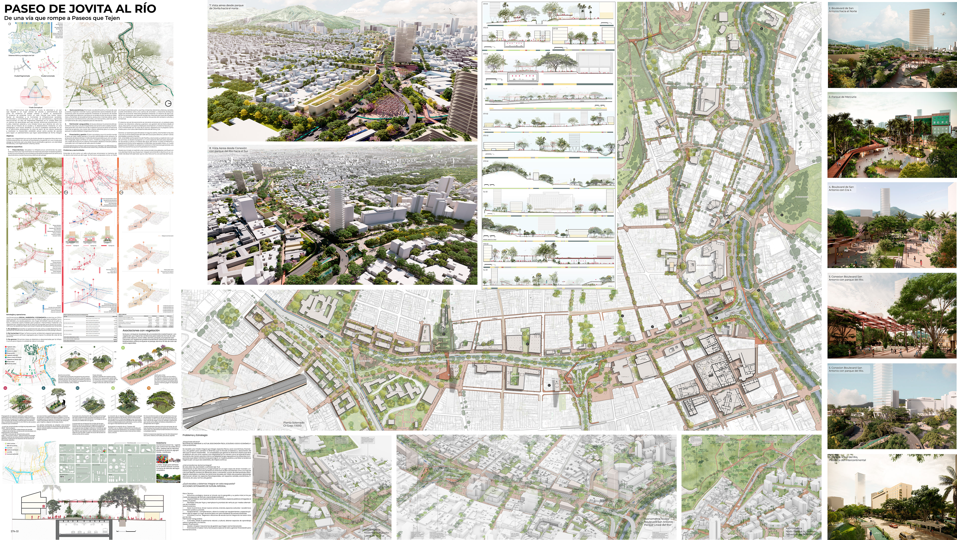
_AXONOMETRIC VIEW JOVITA_
_PROBLEMS AND OPPORTUNITIES_
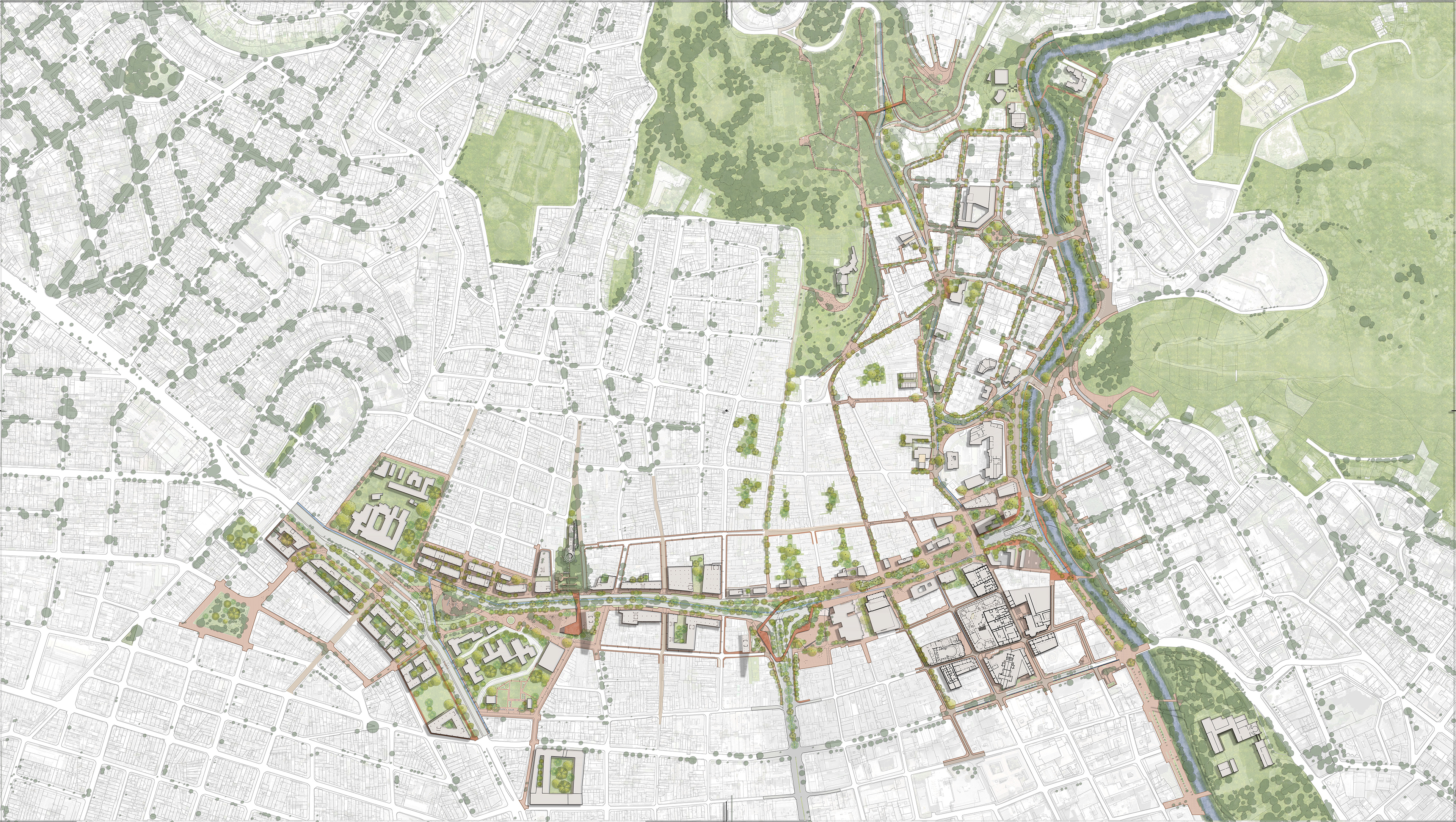
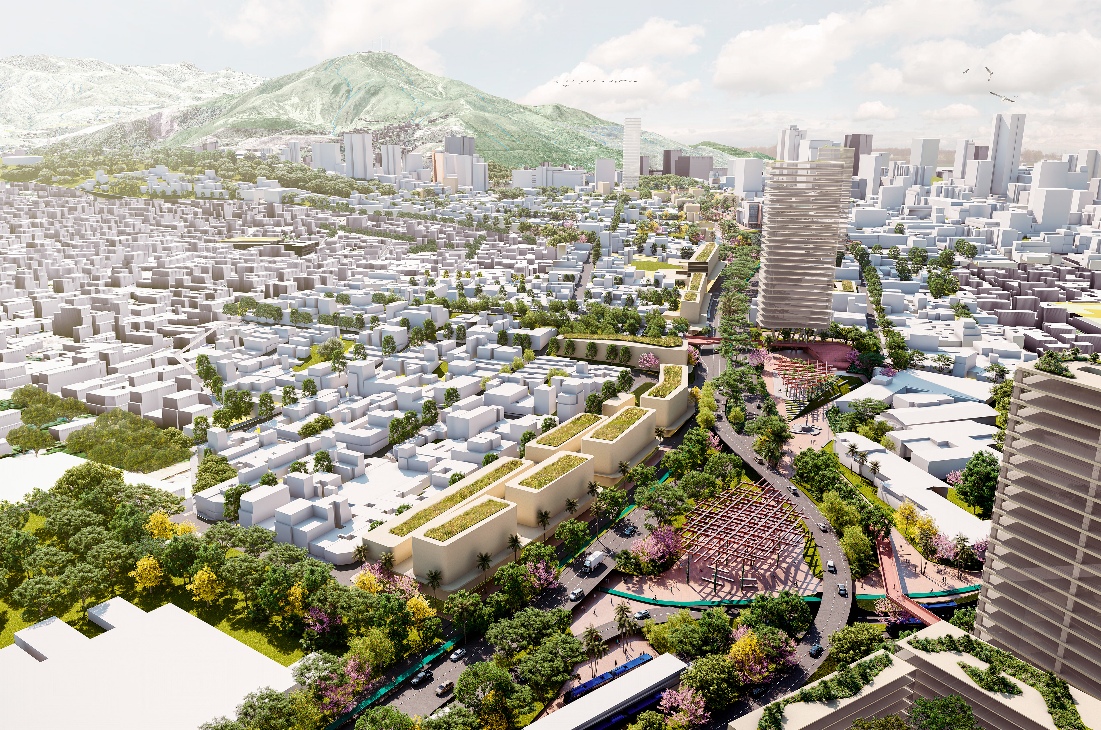
Understanding the site as a cultural valley that reincorporates the memory of the river within the reading of the place. The proposal is formulated as a Delta in which fifth avenue, which today breaks urban and social relationships, can be understood as a basin of activity and ecological relationships capable of reconnecting lost relationships through a system of axes that, transversally, go weaving the neighborhoods, while making the arrival at the river an urban meander that increases the cultural and environmental contact points.
The natural runoff system then becomes a pretext to renew urban relations and generate land management based on water, seen as an opportunity to recompose a natural and cultural system made invisible by the layout of the farm, reappears in the project as means for a new strengthened identity of the site and Cali.
Generate a scenario to strengthen the pride of Cali, retaking the cultural richness and diversity of the Cauca Valley to detonate and attract new activities, actors and forces.Cali, understood as the epicenter of the Pacific, retaking its tradition of crossroads, is from the project a new space for the country to represent ethnic groups and culture, the history of water, sugar, salsa, Petronio and gastronomy among other aspects intangibles that may have a new space to strengthen their national and international presence, generating an economic dynamic that has been lost in the future.
From this point of view, tradition and new global trends come together in an approach that seeks to be comprehensive, turning La Quinta into an exemplary development corridor that envisions it as an avenue of the future.
_AXONOMETRIC VIEW WALKING PASSAGE_
From an infrastructure that favors the car, speed and an unreadable landscape to a porous place of pauses and stays that highlights the urban landscape and facilitates appropriation.
The project is understood as a cultural valley that seeks to reconfigure, renaturalize and rehumanize the infrastructure, slowing it down and turning it into a place of permanence and meaning, structuring a site of scattered fragments in the unity given by a learning park that weaves actors, dynamics economic and cultural, urban systems and a future look that comes from a narrative of the history of the city and the department through a pedagogical leisure that seeks to strengthen the civic culture by valuing the pre-existing heritage. It is about starting from the existing values and recognizing the current unsustainable condition as starting points to achieve an approach that achieves sustainability in an integral way.
•The Territorial: Understood as the succession and intertwining of spaces with development potential for the creation of mechanisms that contribute to the decision-making process, in terms of revitalization, connectivity and urban articulation in an integral way.
•The Population: Seen from a socioeconomic panorama that consolidates the relationship between the activity of the area, the people and their relationship with the environment from the perspective of use and exploitation framed in processes of recovery of public space. The success of the management process is part of understanding the context and knowing how to determine what is or is not convenient for the affected population regarding the territorial decisions that are made, and the appropriate moment to make them, including the different groups in the management, so The idea of NODO facilitates these territorial co-creation tables.
•The Institutional: Links and relationships between key actors in the process belonging to both the public and private sectors and academia in terms of management, investment, administration, maintenance, monitoring, control and continuous improvement.
The interaction of the dimensions and areas must make up the structure that enables a joint and coordinated operation of multiple actors, interests, and entities that generate sufficient management capacity, autonomy, and public-private agreements to make the project viable at its different scales. For this reason, the approach understands the NODE, as an efficient mechanism to land the vision and objectives of the plan in its different areas.
_AXONOMETRIC VIEW OF THE MOUNTAIN_
"From a path that breaks to walks that weave"
_A future vision of Valle del Cauca that updates the infrastructure, taking away the importance of the vehicle to return it to vital energy_
The very scale of the project and its longitudinal condition could be understood as a problem, since generating changes in the short and medium term in such a vast territory is a difficult bet to achieve. In this sense, the approach proposes to approach the intervention through links that are building different transformation points which in time will be putting together the great promenade which will be composed of a succession of intertwined urban pieces.
THE GENERAL PLAN. A large-scale intervention is organized that will be carried out over time through specific interventions that give a specific character to each place while weaving the scale of the landscape and the city.
THE NODES / MANAGEMENT UNITS. The plan is chained over time through intermediate and small-scale interventions that make management viable by bringing together few actors (private and public) while allowing measurement and adjustments to be made with the lessons of each development to balance the successes. and mistakes in time.
_RIVER PASSAGE_
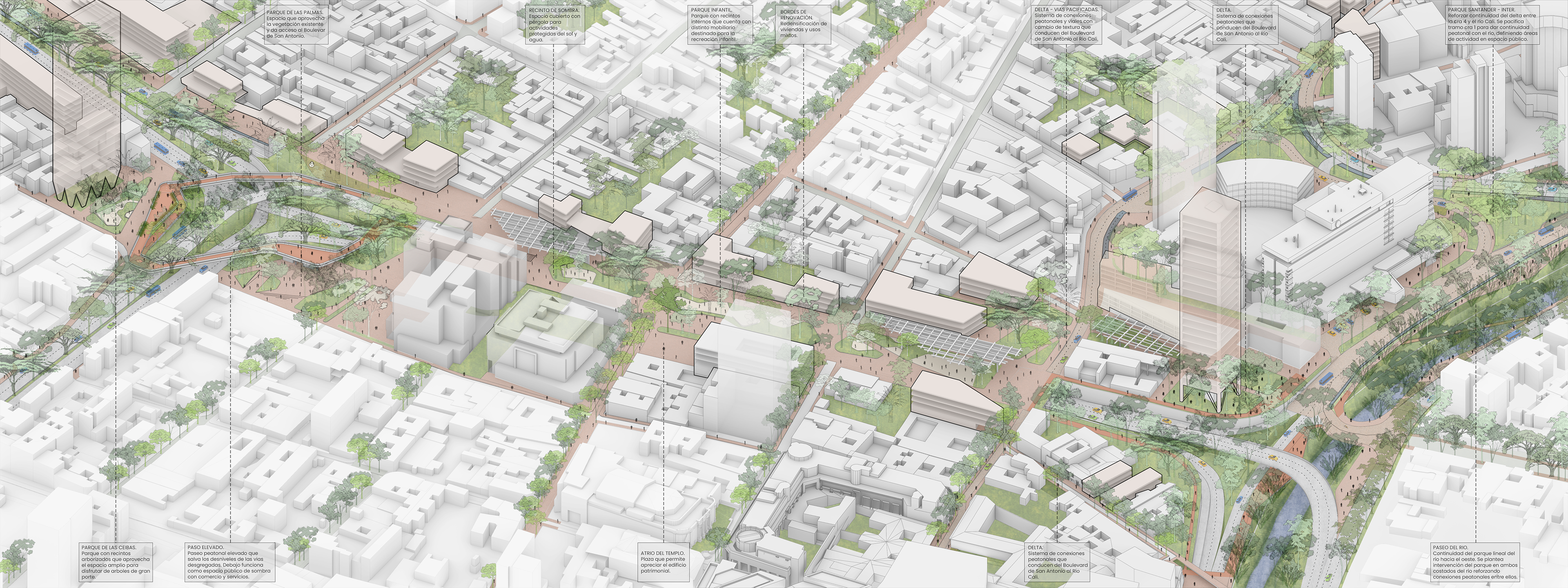
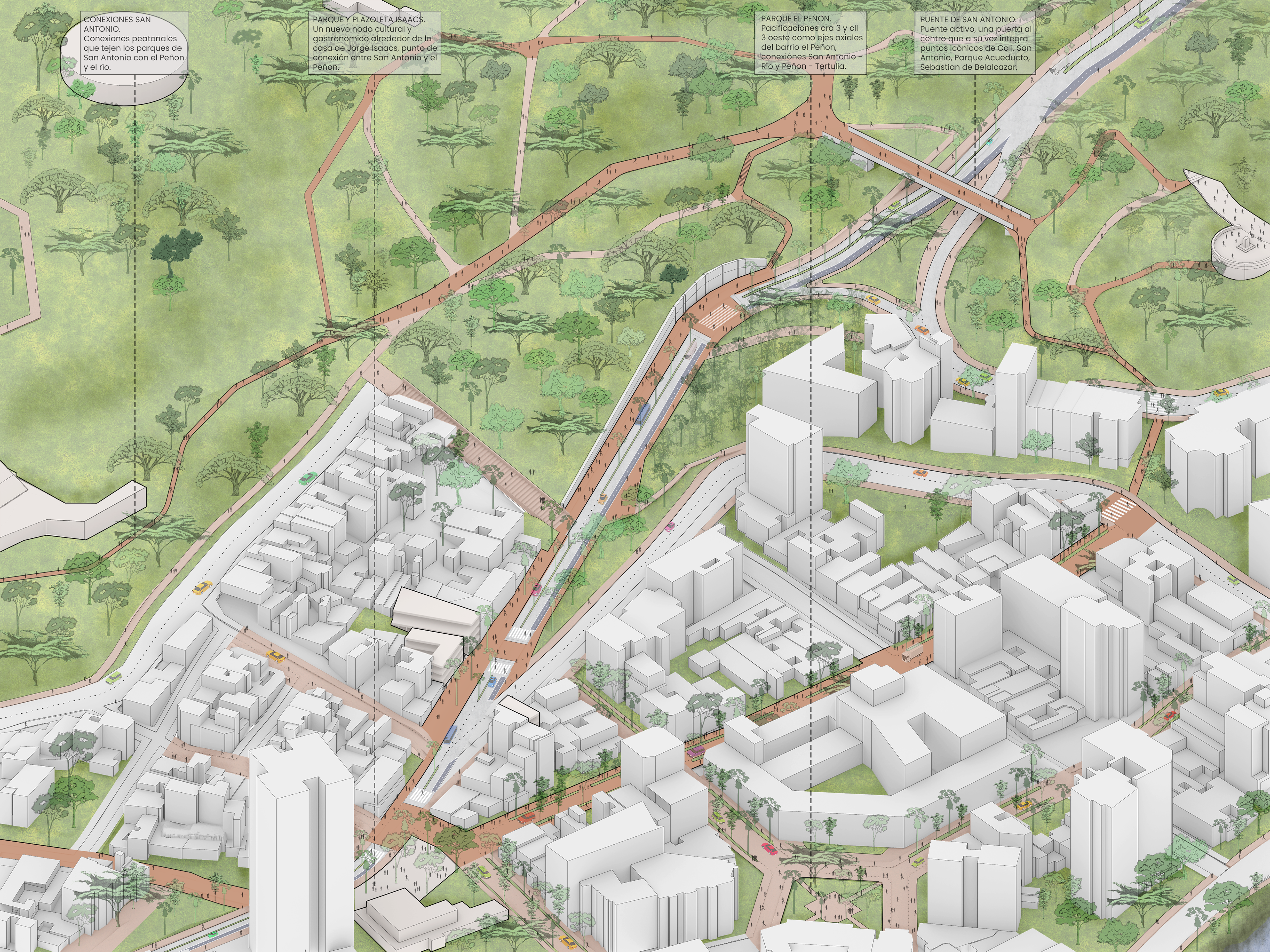
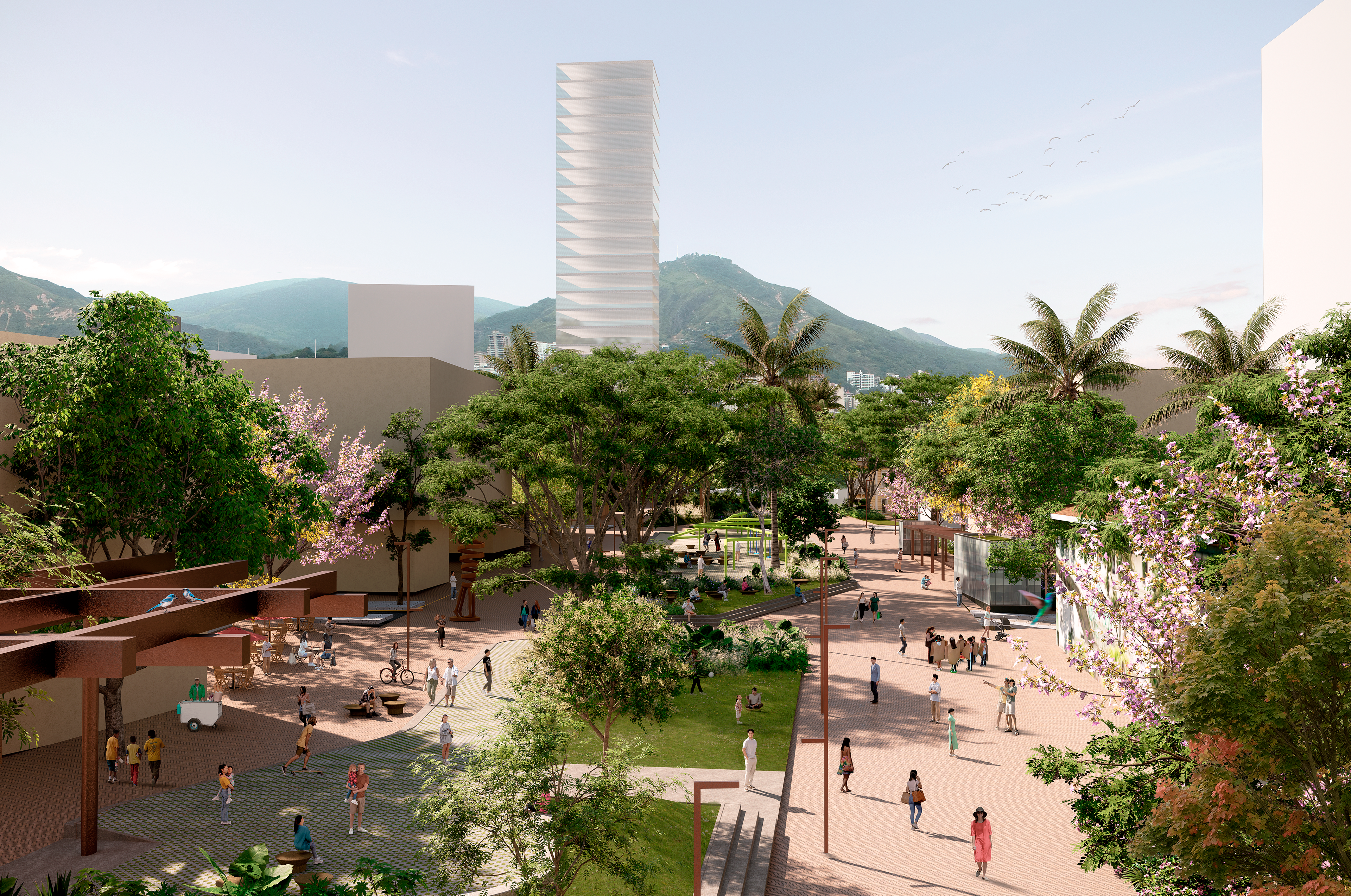
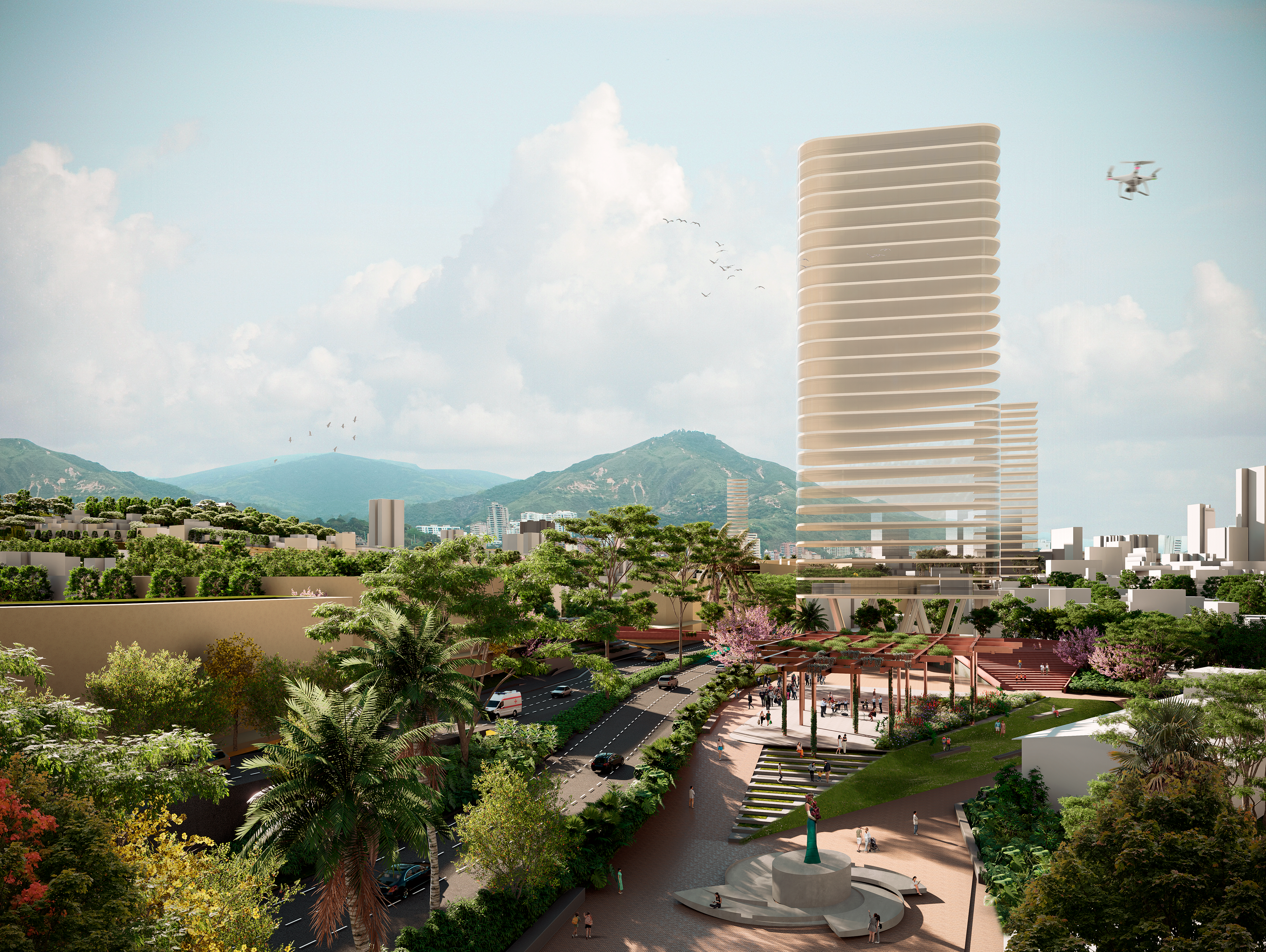
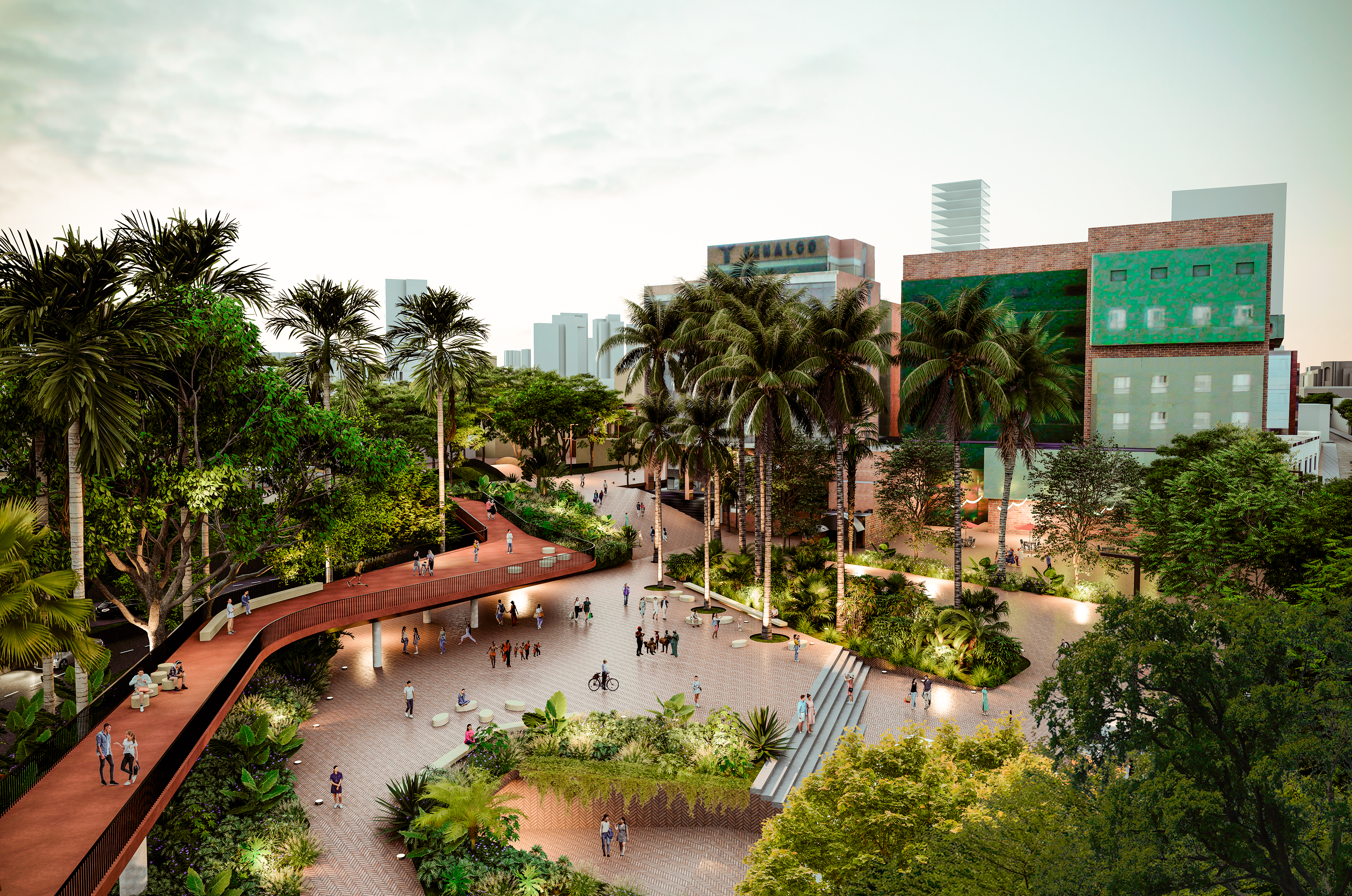
THE NODE is a comprehensive and transversal proposal that seeks to facilitate the management of the plan over time while giving a specific character to each area through strategic projects that can trigger transformations in the short and medium term. These are points in which the development revolves around the creation of a new public space or requalification of existing space in which the presence of the vehicle gives way to the green and the pedestrian. In the nodes, the aim is to insert new housing, mixed uses, equipment when possible and generate exchange stations to facilitate intermodal transport that leads to a disincentive for private cars in the area. They are places for learning about nature and historical culture, and they are laboratories for the creation of a civic culture and care, and they are sites for the regeneration of ecosystems and the integration of urban, social, and economic fabrics.
The nodes are.
•Ideal sites for the location of intermodal transport stations and the articulation of alternative forms of mobility.
• Dissuasive parking for cars and bicycles, as well as public restrooms and services that each area requires.
•They must weave surrounding public spaces and generate new public spaces.
•They must promote real estate development framed by the mix of uses with a prevalence of diverse housing, as well as high-risk urban environments.
pedestrian quality.
•They must renew existing support infrastructures (public services and equipment).
•They must fulfill a function of regenerating ecosystems and generating learning about them.
•There must be an institutional arrangement that allows the management of the walk to be exercised in the long term but at the same time, there must be a space for congregation
of the community that promotes participatory planning of the environment, promoting the strengthening of the appropriation of the city. In this sense, the node is a physical representation of the new institutions and the interactions between them around the promenade and the river, so they become spaces for management and participation.
•The nodes must be autonomous but interdependent. They interact and complement each other. The character of each node is given by its location along the promenade.
•The nodes must be interconnected by environmental corridors that allow the regeneration of the ecosystems, as well as the mobility of the citizen and the collection and reuse of water understood as the ordering theme of the systems.
•The nodes adapt to the urban pre-existences, giving them an identity and a new value for their appropriation, regenerating the urban character and making the territory, its memory and future bets legible.
•The nodes must be meeting places and pedagogy, places to strengthen culture and facilitate rooting.
_INTEGRATION ISLANDS_
It is proposed as a long-term roadmap with activities in the short, medium and long term where political-administrative actions and resources that come from different sources and functional entities that must materialize in the qualification of the Territory must be articulated. To make the construction of the project real over time, the plan seeks through the nodes to use intermediate scale instruments such as partial plans or other management mechanisms that could facilitate the development of the different parts of the plan over time as they allow an articulated management by private actors aligned by the public ones.
With the management of the Plan, it is sought to be:
•Institutionally efficient and flexible
•Environmentally sustainable around public space, greenery and water
•Institutionally efficient and flexible
•Environmentally sustainable around public space, greenery and water
•Socially participatory
• Territorially balanced, linked and integrating
•Economically rational
It is thought that due to the different interventions proposed, in addition to the modification in land use and buildability and the better urban and environmental conditions, it is considered that the value of the land will increase with a different trend from the current one. It is stated that in the short, medium and long term the real value (without taking into account the natural increase in prices) increases continuously. In accordance with the above, it is estimated that the value and the real change in the value of the land for the nodes and their intervention areas must have instruments on the part of the city to generate that capture of value.
_MONUMENT REGENERATION_
Given that important actions on public space have been proposed, their sustainable financing requires an appropriate intervention mechanism that allows ensuring that these places are always available and in ideal conditions for appropriation by the population. It is for this reason that it is suggested to implement mechanisms in very specific areas of intervention.
A possible path may be the one set forth by the national regulations that regulate the Orange Development Areas (ADNs) as a strategy to seek private investment through tax incentives such as the reduction of income tax or the carrying out of works for taxes with the aim of improving the space and public infrastructure as well as Assets of Cultural Interest.
According to Decree 697 of 2020, "ASNs based on the cultural and creative offer are spaces that operate as centers of economic and creative activity, contribute to urban renewal and the improvement of the location area, create a favorable environment in which the Initiatives in these fields strengthen entrepreneurship, employment based on creativity, tourism, the recovery of built cultural heritage, environmental conservation, knowledge transfer, a sense of belonging, social inclusion and citizen access to the offer cultural and creative.
_THE PLAZA_
_Financing of the urban operation_
The proposed interventions value and make all the areas around the NODES attractive for investment. Therefore, to finance these interventions, different mechanisms are proposed:
• Capture part of the value of the land, since its financing may depend on its valuation. These higher soil values depend on:
•For mobility interventions: better access, intermodal transport.
•Due to the concept of compact city or proximity urbanism, there is better and faster access to services, shops, public spaces.
•For mobility interventions: better access, intermodal transport.
•Due to the concept of compact city or proximity urbanism, there is better and faster access to services, shops, public spaces.
•For better urban quality through planning on a human scale.
•Greater investment attraction at regional and international level.
•Instruments that can be used to capture this greater value:
•Greater investment attraction at regional and international level.
•Instruments that can be used to capture this greater value:
•Participation in goodwill
• Contribution in recovery
• Unified property tax
• Equitable sharing of burdens and benefits
•Urban reform bonds
•Tax Increment Financing
•In addition to land value capture instruments, it is also relevant to have other applicable financing sources.
• Contribution in recovery
• Unified property tax
• Equitable sharing of burdens and benefits
•Urban reform bonds
•Tax Increment Financing
•In addition to land value capture instruments, it is also relevant to have other applicable financing sources.
• Future validity of the nation
•Applicable future terms
•General Royalty System
•Economic use of public space
• Aqueduct and sewage billing
•Tax exemptions and local taxes
•Compensation through assignment of construction rights.
•Applicable future terms
•General Royalty System
•Economic use of public space
• Aqueduct and sewage billing
•Tax exemptions and local taxes
•Compensation through assignment of construction rights.
_GENERAL VIEW_
_FINAL LAYOUT_